
As one crosses over Alum Creek – driving up the East Broad Street hill – the expansive open space of Wolfe Park, the St. Charles campus and the grand Bullitt Park Addition mansions defines East Broad Street as a high end, elegant boulevard.
In the early 1920’s, the area east of Cassingham, along East Broad Street, was largely rural and undeveloped — providing investors additional real estate opportunities to develop equally distinctive neighborhoods.
BACKGROUND…
In 1909, Charles Johnson, a Columbus attorney turned developer, purchased acreage west of North High Street, south of the Park of Roses, to create a neighborhood called “Northmoor“. The layout of the streets in Northmoor was quite different from the grid streets further south on High Street – they meandered down the slopes to Northmoor Park along the Olentangy River. This layout seemed more natural, more sympathetic to the contours of the land – less forced than the relentless grid pattern of typical city streets.
Johnson then went further north on High Street and, in 1914, purchased Joseph Jeffrey’s summer home, Beechwalde (the site of the first Columbus zoo – which failed in 1905, after just 10 years of operation, and the property sold to Joseph Jeffrey.)
Johnson hired William Pitkin, Jr., from Rochester, New York – one of the nation’s leading landscape architects – to design a totally organic road layout for the site that featured the natural beauty with its rolling topography.
Pitkin also designed (for the Thompson Brothers) the land plan for Upper Arlington – again utilizing and accenting the hills and valleys of the Miller Farm in his plans. The layout had gently sweeping curves and special open space features created at street intersections.
BACK TO EASTMOOR…
In 1923, Johnson found an opportunity to repeat his formula on the east side of Columbus by purchasing a large tract of land from Henry Stanbery and creating Eastmoor.
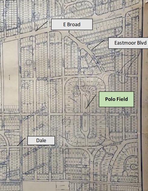
Seeking a road layout that was different from Bexley’s end-to-end grid – yet having limited natural features to work with – Johnson established a Polo Club as the central feature for the development. The layout was a modified grid with a grand avenue, Eastmoor Boulevard, gently curving through the heart of the property, again, creating green spaces at intersections.
The polo field was bounded by South Harding, Elbern, Eastmoor Boulevard, and Dale. The houses on these streets backed onto the polo field and included horse barns.
Within a short time, the Eastmoor Polo Clubhouse burned to the ground and, in partnership with Walter Jeffrey, the Rocky Fork Hunt and Country Club and nearby polo fields were established further east along Clark State Road, in Jefferson Township.
The Eastmoor polo field was then replaced with South Virginia Lee Road – which boasts a large attractive center green space.
Learn more about Eastmoor at the Eastmoor Civic Association and Blockwatch website.
Written by Lawrence Helman, Bexley Historical Society Trustee
Edited by Martina Campoamor, Bexley Historical Society Trustee
2022
If you have information to add to this topic, please let us know.
All comments are reviewed before posting.